Class 6 Geography Chapter 2 Notes:- GLOBE: Latitudes And Longitudes
In this post, we provide Class 6 Geography Chapter 2 Notes:- Globe: Latitudes and Longitudes. In class 6th Geography chapter 2 notes you will read about the Globe, the axis used in the globe, the Heat zone of the Earth etc.
Table of Contents
Globe
Globe is a true model (miniature form) of the earth.
- It is of wearing size and type
- Globe is not fixed it can be rotated the same way as a top spin or a Porter wheel is rotated
- On the globe countries, continents And oceans are shown in their correct size
Axis
- Needle that fixes through the globe in a tilted position is called the axis.
- It pass through their 2 points called poles the North Pole and the South Pole.
- The globe can be moved around the needle from west to east. ( same as the earth’s direction ).
The earth does not have any such needle it moves around an imaginary line.
Equator
- It is an imaginary circular line placed horizontally which divides Earth into two equal parts called the Equator.
- Northern hemisphere- Northern half of the earth is called the Northern hemisphere.
- The southern hemisphere- the southern half of the earth is called the Southern hemisphere
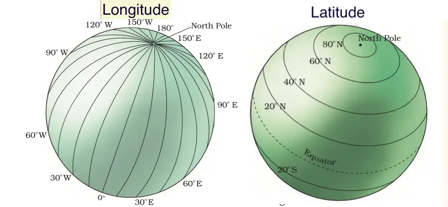
- All The parallel circles from the equator to the pole are called parallel latitude.
- The equator represents 0° latitude.
- The distance from the equator to either pole is 1/4th of the circle which round the earth so it will measure 1/4th of 360°, that is 90°.
- North Pole- 90° north latitude.
- South Pole- 90° South latitude.
- All parallels which are North of the equator are called North latitude similarly all parallels which are the South of the equator are called South latitude.
- The value of these latitudes is represented by the letter N or S.
- The earth is a sphere so as we move away from the equator towards the pole the size of the parallel latitude decreases.
Important parallels of latitude:-
- The Equator is 0°
- North Pole- 90° N
- South Pole- 90° S
There are four important parallels between latitudes also.
- Tropic of Cancer (23½° N) in the Northern Hemisphere.
- Tropic of Capricorn (23½° S) in the Southern Hemisphere.
- Arctic Circle at 66½° north of the equator.
- Antarctic Circle at 66½° south of the equator.

Heat zone of the earth
Torrid Zone:–
The midday sun is exactly overhead at least once a year on all latitudes in between the Tropic of Cancer and the Tropic of Capricorn. This area receives the maximum heat and is called the Torrid Zone.
Temperate Zones:-
The areas bounded by the Tropic of Cancer and the Arctic Circle in the Northern Hemisphere, and the Tropic of Capricorn and the Antarctic Circle in the Southern Hemisphere, have moderate temperatures. These are, therefore, called Temperate Zones.
Frigid Zones:-
Areas lying between the Arctic Circle and the North Pole in the Northern Hemisphere and the Antarctic Circle and the South Pole in the Southern Hemisphere are very cold. It is because the sun does not rise much above the horizon. Therefore, its rays are always slanting and provide less heat. These are, therefore, called Frigid Zones.
Meridians:-
Longitude is the lines of reference running from the North Pole to the South Pole which are perpendicular to the equator. These are called the meridians of longitude, and the distances between them are measured in ‘degrees of longitude.’ Each degree is further divided into minutes, and minutes into seconds. They are semi-circles and the distance between them decreases when we go towards the pole and become zero at the pole, where all the meridians meet.
Prime Meridian-
Unlike parallels of latitude, all meridians are of equal length. Thus, it was difficult to number the meridians. Hence, the count should begin from the meridian which passed through Greenwich, where the British Royal Observatory is located. This meridian is called the Prime Meridian.
- Its value is 0° longitude
- from it, we count 180° eastward as well as 180° westward.
- The Prime Meridian divide the earth into two equal halves,
- The Eastern Hemisphere and the Western Hemisphere.
- Therefore, the longitude of a place is followed by the letter E for the east and W for the west.
- Note that 180° East and 180° West meridians are on the same line.
With the help of longitude and latitude, you can locate any point on the globe very easily.
LONGITUDE AND TIME
The movement of the earth-moon and the planet help us to measure time. When the Prime Meridian of Greenwich has the sun at the highest point in the sky, all the places along this meridian will have midday or noon.
As the earth rotates from west to east, those places east of Greenwich will be ahead of Greenwich time and those to the west will be behind it.
The rate of difference can be calculated as follows.
- The earth rotates 360° in about 24 hours, which means 15° an hour or 1° in 4 minutes.
- Thus, when it is 12 noon at Greenwich, the time at 15° east of Greenwich will be 15 × 4 = 60 minutes, i.e., 1 hour ahead of Greenwich time, which means 1 p.m.
- But at 15° west of Greenwich, the time will be behind Greenwich time by one hour, i.e., it will be 11.00 a.m. Similarly, at 180°, it will be midnight when it is 12 noon at Greenwich.
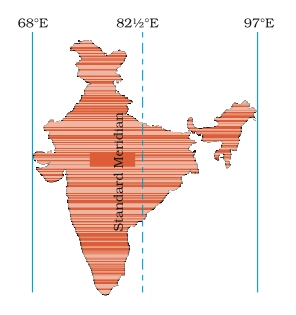
Why do we have Standard Time?
The local time of different places which are on different Meridian is different.
In India, there will be a difference of about 1 hour and 45 minutes in the local times of Dwarka in Gujarat and Dibrugarh in Assam. Therefore, it is necessary to adopt the local time of some Central Meridian of a country as a standard time zone for the country. In India, the longitude of 82½° E (82°30′ E) is treated as the standard Meridian.
India located east of Greenwich at 82°30′ E is 5 hours and 30 minutes ahead of GMT.
Some countries have a great longitudinal extent and so they have adopted more than one standard time. For example, In Russia, there is 11 Standard Time.
The earth has been divided into twenty-four time zones of one hour each. Each zone thus covers 15° of longitude.
Question Based on Globe: Latitude And Longitudes
-
What is a globe?
A globe is a true model (miniature form) of the earth.
-
What do latitudes and longitudes on a globe represent?
Latitudes and longitudes represent the coordinate system used to locate places on the Earth’s surface.
-
What is the axis of the Earth?
The axis is an imaginary line that passes through the North Pole and the South Pole around which the Earth rotates.
-
Define the equator.
The equator is an imaginary circular line placed horizontally that divides the Earth into two equal parts, the Northern Hemisphere and the Southern Hemisphere.
-
What are the Northern and Southern Hemispheres?
The Northern Hemisphere is the half of the Earth north of the equator, and the Southern Hemisphere is the half of the Earth south of the equator.
-
What are the key parallels of latitude?
The key parallels of latitude are the Equator (0°), Tropic of Cancer (23½° N), Tropic of Capricorn (23½° S), Arctic Circle (66½° N), and Antarctic Circle (66½° S).
-
What are the heat zones of the Earth?
The heat zones of the Earth are the Torrid Zone, Temperate Zones, and Frigid Zones.
-
What defines the Torrid Zone?
The Torrid Zone is the area between the Tropic of Cancer and the Tropic of Capricorn where the midday sun is exactly overhead at least once a year.
-
Describe the Temperate Zones.
The Temperate Zones are the areas between the Tropic of Cancer and the Arctic Circle in the Northern Hemisphere, and the Tropic of Capricorn and the Antarctic Circle in the Southern Hemisphere, characterized by moderate temperatures.
-
What characterises the Frigid Zones?
The Frigid Zones are areas between the Arctic Circle and the North Pole in the Northern Hemisphere, and the Antarctic Circle and the South Pole in the Southern Hemisphere, characterized by very cold temperatures.
-
What is the Indian Standard Time (IST) based on?
IST is based on the longitude of 82½° E (82°30’ E), which is 5 hours and 30 minutes ahead of GMT.
Class 6 Geography all Chapter solution:-
| Solution |
|---|
| Class 6 Geography Chapter 1 Solution:- The Earth In the Solar System |
| Class 6 Geography Chapter 2 Solution:- Globe: Latitudes and Longitudes |
| Class 6 Geography Chapter 3 Solution:- Motion of the Earth |
| Class 6 Geography Chapter 4 Solution:- Maps |
| Class 6 Geography Chapter 5 Solution:- Major Domains of the Earth |
| Class 6 Geography Chapter 6 Solution:- Major Landforms of the earth |
| Class 6 Geography Chapter 7 Solution:- Our Country – India |
| Class 6 Geography Chapter 8 Solution:- India: Climate, Vegetation, and Wildlife |
We hope you like the CBSE notes of class 6 geography chapter 2. please share this post to help others and appreciate our team.